|
|
"A comprehensive, collaborative elections resource."
|
South Surrey–White Rock–Cloverdale
|
|
| Parents |
> Canada > British Columbia > BC House of Commons
|
 |
| Established | June 28, 2004 |
| Disbanded | October 20, 2015 |
| Contributor | Monsieur |
| Last Modified | RP August 01, 2015 04:37pm |
| Description |
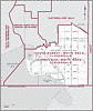
Located on the Lower Mainland abutting the U.S. border, this riding has Mud Bay and Boundary Bay as its west boundary. It includes White Rock as well as that part of Surrey south of the Serpentine River, 160th Street, 72nd Avenue and the Fraser Highway.
The 2001 census found 21 per cent of residents here were immigrants and 18 per cent were older than 65.
This riding's economy is made up of light manufacturing and related service work. Average family income was $82,915 in 2001 and unemployment was just 4.7 per cent.
Surrey-White Rock was established in 1986. The name changed to Surrey-White Rock-South Langley in 1990 and South Surrey-White Rock-Langley in 1996. It became South Surrey-White Rock-Cloverdale in 2004, by taking the bulk of South Surrey-White Rock-Langley and adding in about 27,000 residents of Surrey Central.
Population: 99,317
|
 | INFORMATION LINKS |
|
|
| VOTER REGISTRATION |
|
|
| DEMOGRAPHIC |
|
|
| MEDIA |
|
|
|
|